Living in Japan means learning how to prepare for earthquakes in practical ways. Knowing how to find evacuation site in Japan is just as important as having an emergency kit ready. In the first post of this series, we covered how to prepare your earthquake emergency kit — what to include and where to buy essential items. If you haven’t read that yet, I recommend checking it out first because having your kit is the foundation of being prepared!
Once your emergency kit is ready, the next vital step is understanding how to find your evacuation site — the safe places designated by local governments where you and your family can gather after an earthquake or other disasters. I’ve experienced several tremors here, and I know how stressful and dangerous it can be when you don’t know where to go. For many foreigners living in Japan, finding and remembering evacuation sites can feel confusing, especially with much of the information in Japanese. In this post, I’ll share simple, practical steps and official resources to help you quickly locate and remember your nearest evacuation site.
What Is an Evacuation Site in Japan?
Evacuation sites, called 避難場所 (hinan basho) in Japanese, are designated safe areas where people gather immediately after an earthquake, tsunami or emergency. These locations include schoolyards, parks, or public halls chosen because they are relatively safe from falling debris or landslides.
They include:
- Temporary evacuation sites for initial gathering
- Designated evacuation shelters for longer stays
Everyone in the neighborhood, including foreigners, is welcome to use them.
There are several types of evacuation site for earthquake, tsunami, flood, or landslide. It’s very important to know in advance which place is appropriate to use in case of emergency.
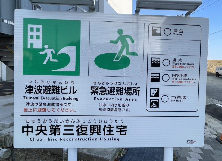
📍 Common Evacuation Site Pictograms in Japan
Japan uses simple, easy-to-recognize pictograms to indicate different types of evacuation sites. Here are the four main ones you’ll often see:
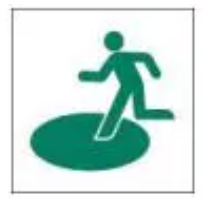
Image from 防災新聞
🏃 Evacuation Site (避難場所 / Hinan Basho)
This symbol shows a person running into a green area. It marks a temporary open-space evacuation site, like a park or schoolyard, where people gather right after an earthquake or tsunami. In case of earthquake, avoiding the falling objects from the buildings outside is very important.
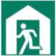
Image from 防災新聞
🏫 Evacuation Shelter (避難所 / Hinanjo)
This icon usually features a person entering a building. It indicates a shelter where people can stay for longer periods after evacuating. These sites often include basic necessities like water and blankets.
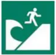
Image from 防災新聞
🗻 Tsunami Evacuation Site (津波避難場所 / Tsunami Hinan Basho)
This pictogram shows a person running uphill toward a wave. It’s found in coastal areas and guides people to high ground to escape tsunami risk.
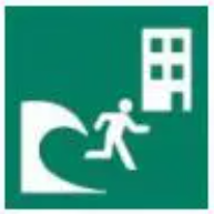
Image from 防災新聞
🏢 Tsunami Evacuation Building (津波避難ビル / Tsunami Hinan Biru)
This symbol typically shows a tall building with arrows pointing upward. These are reinforced high-rise buildings specifically designated as safe places during a tsunami. In urban coastal areas where there is no time to reach higher ground, these buildings provide vertical evacuation to upper floors to avoid floodwaters.
Why You Should Know Your Evacuation Site
When living in Japan, knowing the location of your nearest evacuation site isn’t just a safety tip — it’s a part of daily preparedness. Earthquakes can happen without warning, and when they do, every second counts. Having a plan in mind and knowing exactly where to go can make a big difference for you and your loved ones.
When I first moved to Japan, I honestly didn’t pay much attention to things like evacuation sites or hazard maps. But after feeling a few unexpected tremors — including one that happened late at night and made me stop and think — I realized how unprepared I really was. After that, I checked my local ward’s website and walked to the nearest evacuation site myself. It was a small park with a big open space — somewhere I’d never thought of as a disaster spot before.
Both Japanese residents and foreigners prepare for this together. Local governments provide multi-language resources (including English or Spanish), and communities conduct disaster drills regularly. Knowing your evacuation site ahead of time helps you stay calm and act quickly when it matters most.
Practical Ways to Find Your Evacuation Site in Japan
Here are some easy steps to find your evacuation site:
✅ Check Your City or Ward Office Website
Most ward or city offices publish evacuation site lists and maps online, often with English support. Search “[Your Ward/City Name] evacuation site” on Google. For example:
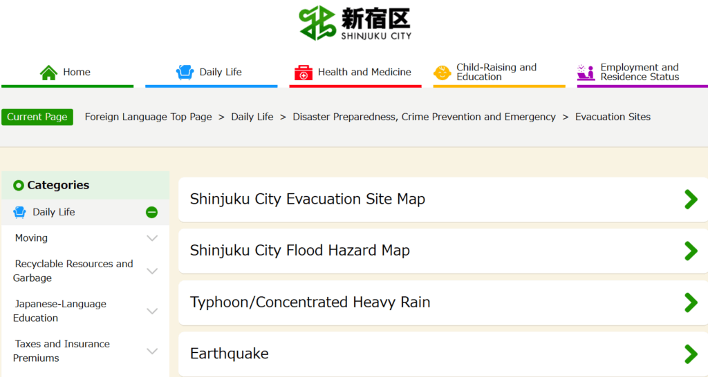
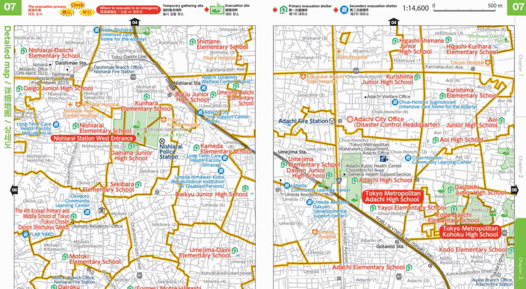
- Adachi City Evacuation Map
✅ Install Local Government Apps for Evacuation Site Information
Many local cities or wards in Japan — such as Tokyo, Osaka, and Yokohama — have their own apps or web-based maps where you can see designated evacuation sites with symbols and directions. These tools are often available in English and are designed specifically for residents, not just visitors.
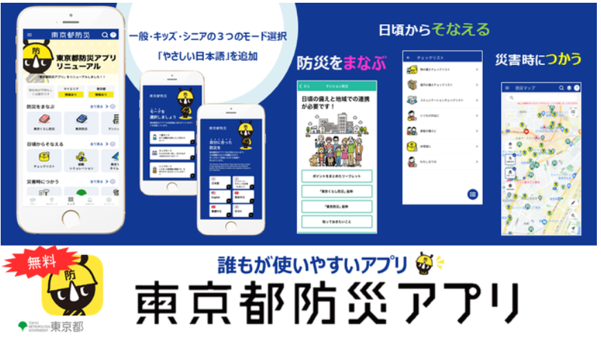
For those living in Tokyo, the Tokyo Bousai App(東京都防災アプリ)is a great tool to locate your nearest evacuation sites. The app provides a map that shows official evacuation sites such as parks, schools, and public facilities. It also includes disaster alerts, safety guides, and a customizable emergency plan feature — and the best part is, it’s free and available in English.

I have been actually using this app from several years ago, and it’s quite easy to use. The map interface clearly shows evacuation sites near my neighborhood, and I was surprised to find that some of them were places I often pass by — like a local elementary school and a community center. By tapping on each site, I could read details such as whether it’s open during a specific disaster, how far (how many minutes/meters away) it is from my current location and the direction itself. Really convenient!
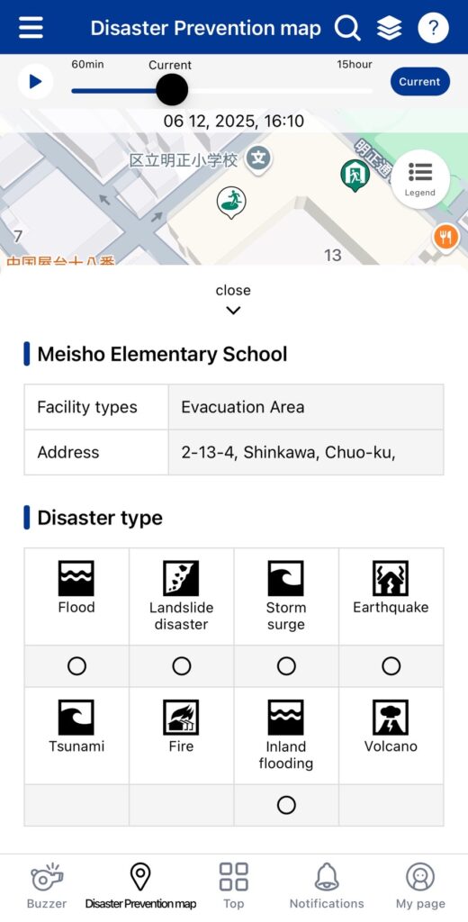
I highly recommend you to download this app if you are living in Tokyo, to check the nearest evacuation site near your home or your company in advance.
✅ Check Signs and Maps in Your Neighborhood
One of the easiest but most overlooked ways to stay prepared is by simply paying attention to your surroundings. In many neighborhoods across Japan, you’ll find evacuation site signs posted near parks, schools, community centers, or train stations. These signs are usually green and include symbols, arrows, and sometimes even maps that show where the nearest evacuation sites are located. Some signs may be in Japanese only, but the pictograms are generally easy to understand once you know what to look for. (Check the symbols that I explained above!)
Taking just a few minutes to explore your neighborhood and mentally note where these signs are can make a huge difference in an emergency.
Tips for Remembering and Preparing for Your Evacuation Site
Once you’ve found your nearest evacuation site, it’s important to make sure you can actually recall it and reach it smoothly in an emergency. I personally walked to my closest sites after checking them on the Tokyo Bousai App — just that short walk helped me feel more confident and less anxious. A little preparation now can save precious time later.
Here are some small but effective things you can do to stay ready:
- Bookmark your local ward’s evacuation map (or app) for quick access.
- Practice walking to your evacuation site at least once, so you remember the route without needing GPS. (In an emergency situation, the internet may not work properly)
- Keep a printed map inside your emergency kit, just in case your phone isn’t available.
Official Websites to Check
Besides this article, I share you some official resources or guide books in English by Japanese local official websites. It contains not only evacuation sites information, but also overall guidelines such as what to do / what to not do in an emergency situation. Don’t forget to check in advance!
- Designation of Evacuation Site and Stayed-in Areas for Fires Caused by an Earthquake in Tokyo Wards by Tokyo Metropolitan Government
- What to do in Case of an Earthquake: Safety and Evacuation by Japan Living Guide
- Earthquake! Tsunami! Evacuate Immediately! by Japan Meteorological Agency(気象庁)
- Evacuee Life Guide for foreign residents by Shizuoka prefecture official website (It’s including overall evacuation guides not only for Shizuoka prefecture)
Final Thoughts
Knowing how to find evacuation site in Japan is a crucial next step after preparing your earthquake emergency kit (see Vol.1 of this series). By checking official information and neighborhood signs in advance, you’ll be ready to act calmly and safely when disaster strikes. Let’s stay safe!
Have any question while living in Japan? I’m here to help you! Please check a ☕coffee chat with me for 1-on-1 help, or check out my other posts for more practical tips on navigating life and work in Japan!

30-Min Coffee Chat – Japan Life Support
66% discount offer available now!
Need help navigating life in Japan? Book a 30-minute Coffee Chat with Mochi for practical and personalized advice — in English, Spanish, Japanese, or Korean.